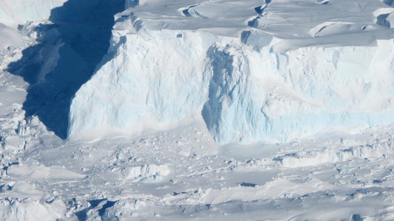
A team led by glaciologists from UC Irvine used satellite radar data to reconstruct the influence of warm seawater on a subsurface zone several kilometers long beneath the Thwaites Glacier in West Antarctica. The research, published in a paper PNAS, will help climate modelers get more accurate predictions of sea-level rise as a result of the melting of sea-stopping glaciers around the world. Credit: NASA/James Yunkel
Satellite radar data show significant seawater intrusion beneath Antarctica Thwaites GlacierCauses snow to rise and fall.
Using high-resolution satellite radar data, a team of glaciologists led by University of California researchers found evidence of warm, high-pressure seawater seeping several kilometers beneath the ground ice sheet of West Antarctica’s Thwaites Glacier. This glacier is often referred to as the “Doomsday Glacier” because of its major role in global sea-level rise and the potentially catastrophic effects such rise could have globally. The nickname reflects the vast size of the glacier and its significant melting rate, which scientists believe could contribute significantly to sea level rise if it collapses or melts completely.
The UC Irvine-led team concluded that widespread contact between seawater and glaciers — a process mirrored in Antarctica and Greenland — is causing “intense melting” and may require a re-evaluation of global sea-level rise projections. Their study was published on May 20 Proceedings of the National Academy of Sciences,
Data and observations
The glacier researchers relied on data collected from March to June 2023 by Finland’s ICEYE commercial satellite mission. ICEYE satellites use the InSAR – Interferometer Synthetic Aperture Radar to continuously monitor changes in the Earth’s surface, forming a “constellation” in polar orbit around the planet. Multiple passes of a spacecraft over a small, defined area provide smooth data results. In the case of this study, Thwaites showed the rise, fall and curvature of the glacier.
“These ICEYE data provide a long-term series of daily observations that closely match tidal cycles,” said lead author Eric Rignot, UC Irvine professor of Earth system sciences. “In the past, we had some sporadic data available, and with those few observations it was hard to figure out what was going on. When we look at continuous time series and compare it to the tidal cycle, we see seawater coming in and out at high tides, sometimes getting stuck far beneath the glacier. Thanks to ICEYE, we are beginning to see this tidal dynamic for the first time.
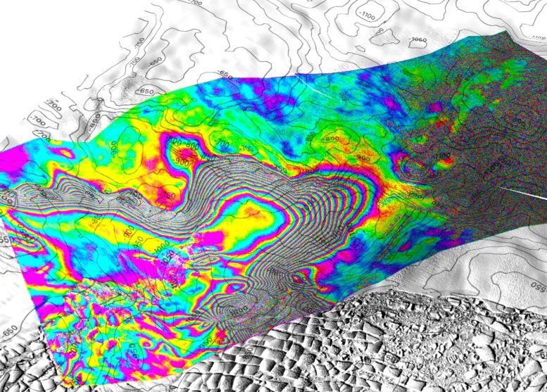
Screenshot of a 3D view of the wave motion of Thwaites Glacier, West Antarctica, recorded by the ICEYE Synthetic Aperture Radar (SAR) constellation based on images acquired on May 11, 12, and 13, 2023. The bed area is 50 m. interval. Each interferometric fringe color cycle is a 360-degree shift in phase, which is equivalent to a 1.65 cm displacement in line of sight of the ice surface. The interferogram is overlaid on a Landsat 9 image acquired in February 2023. In this study, we show that the extent of tidal curvature varies over kilometers in the tidal cycle, indicating that pressurized seawater can penetrate and solidify over kilometers beneath land ice sheets. Heat transfer with glacier base. On the right side of the screen, a single bull’s-eye model shows seawater intrusion spreading a further 6 km beyond a protective ridge, indicating that glacier retreat is still continuing at a rate of one kilometer per year in this critical region of Antarctica. Credit: Eric Rignot / UC Irvine
Advanced satellite observations
“Until now, some of the most dynamic processes in nature have been impossible to observe with sufficient detail or frequency,” said Michael Wollersheim, Director of Analytics at ICEYE, co-author. “Observing these processes from space and using radar satellite images that provide centimeter-scale precision measurements at daily frequency represent a significant advance.”
Rignot said the project helped him and his colleagues develop a better understanding of the behavior of seawater at the base of Thwaites Glacier. Seawater at the base of the ice sheet, along with freshwater generated by geothermal flow and friction, “has to run somewhere,” he said. Water is distributed through natural pipes or collected in vents, creating enough pressure to lift the ice.
“There are places where the water is under a lot of ice pressure, so it takes a little more pressure to push the ice up,” Rignot said. “The water is squeezed enough to raise a column of ice more than half a mile.”
And it’s not just seawater. For decades, Rignot and his colleagues have been gathering evidence of climate change’s impact on ocean currents, which push warmer ocean water toward the shores of Antarctica and other polar ice regions. Circumferentially deep water is saline and less freezing. Fresh water freezes at zero degrees CelsiusSalt water freezes at minus two degrees, and that small difference is enough to contribute to the “extreme melting” of the basal ice found in the study.
Sea level rise and impact on future research
Co-author Christine Dove, Professor in the Faculty of Environment University of Waterloo In Ontario, Canada, “The Thwaites is the most unstable place in the Antarctic, and the equivalent of 60 centimeters of sea level rise. The concern is that we are underestimating the speed at which the glacier is changing, which could be devastating to coastal communities around the world.”
Rignot said he hopes and expects the results of the project to stimulate further research into conditions beneath Antarctic ice sheets, exhibits involving autonomous robots and multiple satellite observations.
“There’s a lot of enthusiasm from the scientific community to go to these remote, polar regions to collect data and build our understanding of what’s going on, but funding has lagged,” he said. “We’re operating in real dollars in 2024 with the same budget as in the 1990s. We need to develop a community of glaciologists and physical oceanographers to quickly solve these observational problems, but right now we’re still climbing Mount Everest in tennis shoes.
Conclusion and implications for modeling
More recently, Rignot, senior project scientist NASAJet Propulsion Laboratory (JPL), said the study will provide lasting benefits to the ice modeling community.
“If we put these kinds of sea-ice interactions into ice models, I expect we can do a much better job of recreating what happened over the last quarter century, which will give us more confidence in our predictions,” he said. “If we can add this process that we outlined in the paper, which is not included in most current models, the model reconstructions should match the observations much better. If we can achieve that it will be a huge success.
Dow added, “We don’t have enough information to say one way or the other how much time there is before seawater intrusion. By improving models and focusing our research on these important glaciers, we will try to correlate these numbers over at least decades and even centuries. The work will focus on reducing carbon emissions to prevent worst-case scenarios and help people adapt to changing sea levels.
Reference: Eric Rignot, Enrico Siraci, Bernd Schüchl, Valentin Dolbekin, Michael Wollersheim, and Christine Dow, 20 May 2024, “Widespread seawater intrusions beneath the ground ice of Thwaites Glacier, West Antarctica” Proceedings of the National Academy of Sciences.
DOI: 10.1073/pnas.2404766121
Rignot, Dow and Wollershiem were joined on the project by Enrico Siraci, a UC Irvine assistant professor of Earth system science and a NASA postdoctoral fellow; Bernd Scheuchl, a UC Irvine researcher in Earth system science; and Valentyn Tolpekin of ICEYE. ICEYE is headquartered in Finland and operates from five international locations, including the United States. This research was funded by NASA and the National Science Foundation.